In short
|
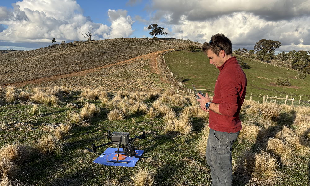
Field staff operating a drone.
Drones in monitoring and research
Drones, also known as Unmanned Aerial Vehicles (UAVs) or Unmanned Aircraft Systems (UASs), are unpiloted aircraft operated remotely or guided by onboard computers. They come in many different types and sizes depending on their intended use. When equipped with sensors such high resolution cameras, thermal imaging and LiDAR (remote sensing technology), they can collect detailed information over large or inaccessible areas. By combining UAV imagery with automated image detection, surveys of individual species at scale can be more cost effective than traditional survey methods.
Growing recognition of the potential use of drones and artificial intelligence (AI) technologies is driving the use of drones in the management of natural ecosystems.
Drones offer the potential to:
- monitor the status of landscapes and species, including threats, changes and trends over time
- monitor and detect changes in vegetation
- map the spread and distribution of invasive species
- identify priority areas for management
- assess the effectiveness of rehabilitation efforts
- rapidly respond to incidents such as extreme weather events
- provide a visual tool to support scientific communication and engagement.
What we are doing
Since 2017, ARI has worked with drones in many environmental research contexts including:
- monitoring population trends of colonial waterbirds on Mud Island, Port Phillip Bay
- identifying, tracking and surveying Southern Right Whales
- testing the suitability and efficacy of different techniques to survey European Rabbits
- classifying and estimating floodplain vegetation in the Mallee and evaluating its response to environmental watering.
Research examples
Understanding population trends is essential for managing species over the long term. Mud Islands in Port Phillip Bay is a major breeding site for more than 40,000 colonial waterbirds and forms part of a Ramsar-listed wetland of international significance. With such large numbers, modern survey methods offer new opportunities to track population change more effectively.
ARI pre-trained computer vision models to identify eight species of colonial nesting waterbirds. These models were then tested on drone imagery to determine their suitability for long-term population monitoring of the waterbird breeding colonies on Mud Islands.
The successful trial showed that these models can estimate populations at the colony scale. Whilst the method tended to underestimate populations, in general all target species could be detected. The trial also highlighted key improvements for future surveys including:
- flying at lower altitudes
- standardising physical conditions (such as season, time of day and weather)
- analysing individual images rather than overlapping mosaics.
Lower altitude surveys are being trialled throughout the 2025 and 2026 breeding season and are expected to provide better resolution for individual species recognition. The project will also establish a standard protocol for monitoring population trends in colony-breeding birds at Mud Islands.
The initial work was funded by the Corangamite Catchment Management Authority and the current project is being funded by the Victorian Government’s Port Phillip Bay Fund.
To learn more about this research, contact Danny.Rogers@deeca.vic.gov.au or Kasey.Stamation@deeca.vic.gov.au.
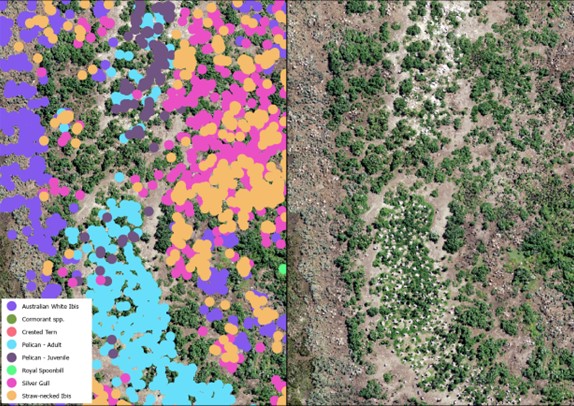
Drone imagery of Mud Islands with model species predictions
Southern Right Whales regularly visit the Victorian coast over winter to give birth, rest and nurse their calves. ARI has a long involvement in identifying, tracking and surveying these whales as well as community awareness and engagement efforts to reduce boat strikes and disturbance.
Between 2017 and 2024, drone surveys have been used to photograph cow-calf pairs to help identify and track individuals. Drone images can help derive body measurements and body condition scores, enabling researchers to non-intrusively conduct health assessments and track the body condition of cow-calf pairs over time.
Drone flights along the entire Victorian coastline improve our understanding of whale distribution, help identify new nursery sites and help fill key knowledge gaps to support management.
This work was funded by various Victorian Government threatened species funding programs including the Icon Species Program.
For more information on this research, visit ARI’s Southern Right Whale page or contact Kasey.Stamation@deeca.vic.gov.au.
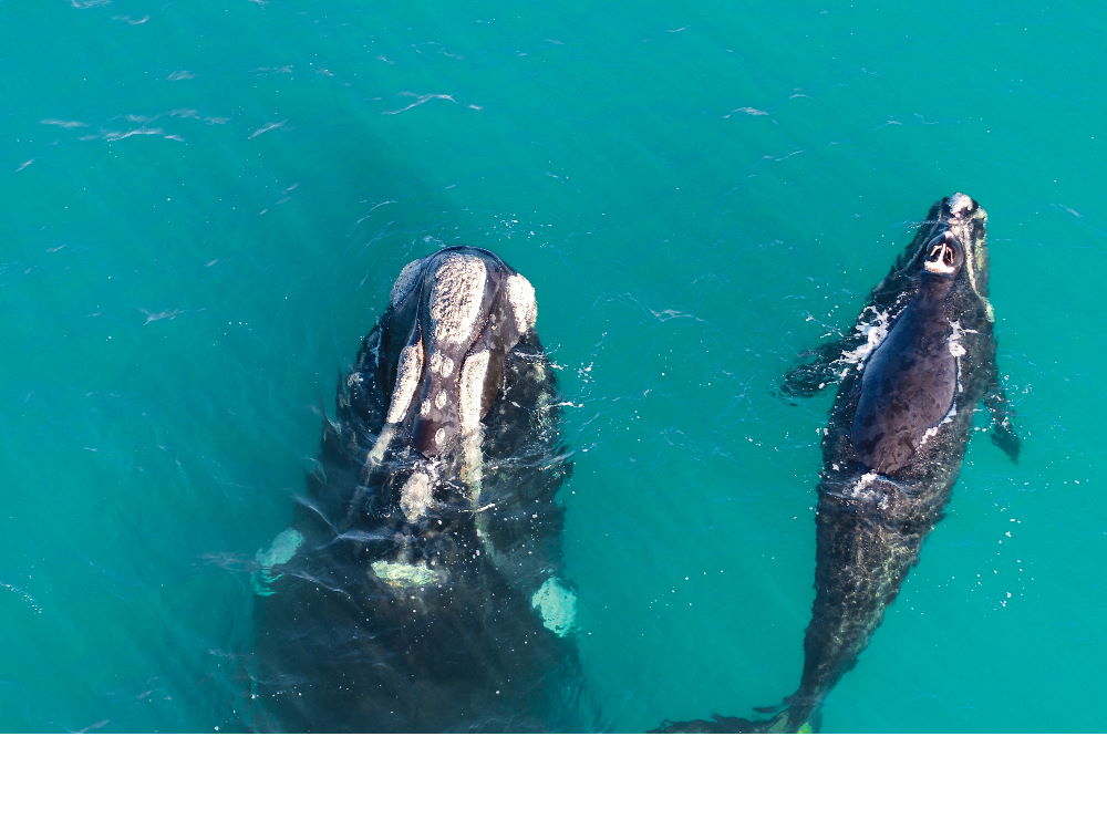
Southern Right Whale with calf - image taken under research permit (no. 10010359) under Section 78 (1) (c) of the Wildlife Act 1975 and Animal Ethics approval (AEC 22-001)
The introduced European Rabbit is one of Victoria’s most destructive vertebrate pests. Warren activity and nighttime spotlight counts are survey methods commonly used to determine Rabbit densities and detect long-term trends in particular areas. These methods are however quite labour-intensive.
ARI’s pilot study investigated the efficacy of using drones tomonitor Rabbits testing the use of different drones and camera arrays (thermal and visual) at a site with high Rabbit densities. This work provided useful insights regarding the suitability of different drone platforms, flight speeds and heights to optimise Rabbit detection. In 2026, trials will be carried out to compare the results of drone surveys with conventional spotlight counts.
This work is funded by Agriculture Victoria. For more information, contact David.Ramsey@deeca.vic.gov.au.
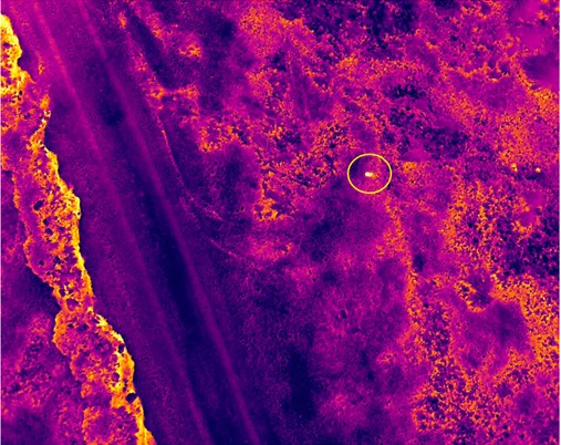
Infared drone image of Rabbit detection at 30m above ground level. Rabbit indicated by yellow circle.
Woody perennial vegetation, including Tangled Lignum (Duma florulenta), is a key part of many Victorian floodplains. Given its ecological importance, environmental water is used to maintain populations of Lignum and aid its regeneration. Field-based monitoring of floodplains can be difficult, due to Lignum’s dense growth habit and limited access during and after inundation.
A recent collaborative study between the University of Canberra and ARI integrated drone imagery and deep machine learning to classify and estimate floodplain vegetation in the Mallee region of Victoria. The project also evaluated floodplain responses to environmental watering. The deep machine learning involved Convolutional Neural Networks (CNNs) which can effectively and accurately classify species, assess plant health, and map vegetation cover.
This drone-based method effectively captured high-resolution data in Lignum shrublands, was found to be an efficient, accurate and repeatable survey approach. Our analysis detected a positive short-term response of Lignum condition to flooding, as well as differences in Lignum condition related to long-term flood regimes.
This new information can help managers support Lignum populations by understanding condition trends, identifying priority areas and guiding decision-making for water management.
This work was funded through The Living Murray Program of the Murray-Darling Basin Authority. To learn more about this research, contact Chris.Jones@deeca.vic.gov.au.
Publications:
- Higgisson, W., Lio, R., Tschierschke, A., Cobb, A., Jones, C., Vivian, L. and Bridgewater, P. (2025) Integrating drone and deep learning technology to monitor floodplain changes in response to environmental flows. Hydrobiologia.
Drone and deep learning technology can be used to monitor Lignum, a key component of floodplains.
Limitations of Drones
The use of drones in environmental science is relatively new and evolving. There is potential for drones to complement or even replace traditional survey methods, often at lower cost and across wider areas. However, their suitability for research and monitoring depends on what ecological issue is being investigated.
There may be challenges and constraints on their usage, potential impacts and disturbance on particular species and interpretation of results.
In Victoria, drone and wildlife regulations, privacy issues, and technical expertise limitations may affect the suitability of drone use. There is also a need for consistent field protocols, guidelines, standards for use and frameworks. Close collaborations between land and water managers, government, researchers, private companies and drone operators are needed to realise the benefits drone may have in supporting environmental management.
How we can help
ARI offers expert support to guide the effective and appropriate use of drones in:
- Project guidance – expert advice on how to best use drones to meet your project goals.
- Project integration – identifying how drones can be incorporated into new or existing monitoring and research programs.
- Filling knowledge gaps – delivering targeted research to improve confidence in drone methods and results.
- Technique development – developing and refining methods for collecting and analysing drone data, as well as options to incorporate artificial intelligence (AI) technologies.
More information
For further information about ARI’s drone expertise contact research.ari@deeca.vic.gov.au
Page last updated: 11/03/26