In short
|
![]()
Field staff using radio tracker. Photo credit: Graeme Coulson
Why do we track wildlife?
Detailed tracking information on animal movement can help scientists understand the ecology of a species. This includes aspects such as their behaviour and use of the landscape, their interactions with other individuals and species, and how they are affected by environmental conditions and changes.
Wildlife tracking studies are often used to investigate:
- Species distribution
- Landscape connectivity
- Habitat use, including critical sites for breeding and foraging
- Migration routes, patterns and timings
- Population health and status
- Spread and impact of invasive species.
By understanding wildlife responses to environmental change such as land-use change, seasonal and climate shifts, anthropogenic activity and threats, we can inform environmental management decisions to achieve better conservation outcomes.
What we are doing
At ARI, we match the best-suited tracking method or technology to answer questions our partners have about the movements of wildlife. We use a variety of tracking methods and technologies; from simple identification tags for mark and recapture surveys to more advanced methods such as acoustic and radio telemetry and satellite tracking.
Each method has a different set of advantages and limitations that must be considered in the context of the research questions and project budget.
How we track wildlife
External tags, bands or markers are a long-standing method of identifying and tracking individuals as part of population monitoring. They can appear as plastic tags, metal bands or light-weight collars attached to the outside body of an animal.
You may have seen fish with thin plastic tags on their dorsal fins or notice birds in the wild with a small metal band around their leg; these are examples of animal tags. For some species, permanent marks are made onto the body, such as notching the edges of turtle shells or tattoos in the ear of large mammals.
External tags are a cost-effective and practical way to identify individuals as part of mark and recapture surveys. They are also ideal for long-term monitoring programs to estimate population size, abundance and survival rates.
Related projects:
- Using external tags as part of an extensive mark and recapture monitoring program of Murray River fish species
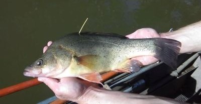 Golden Perch tagged with an external T-bar tag. Photo credit: ARI |  Bar-tailed Godwit with leg band. Photo credit: ARI |
Passive Integrated Transponder (PIT) tags can track individual animals over their lifespan, similar to the microchip used to identify pets. They are inserted into the body of the animal and contain a unique identification code which is read by a handheld scanner when the animal is re-caught.
PIT tags can also be read by antenna readers placed strategically along rivers, including on fishways, providing a valuable and cost-effective method to monitor fish movement, passage through fishways and behaviour.
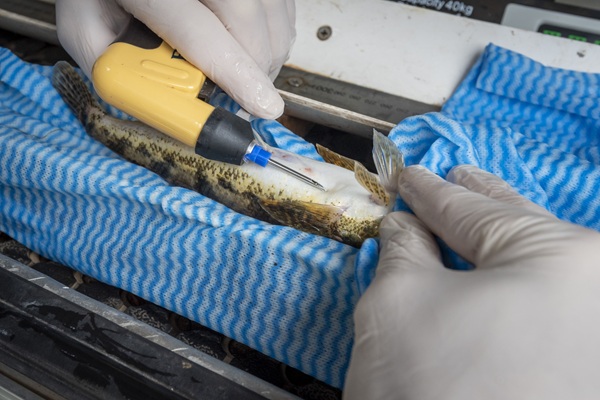
PIT tag being inserted into a Tupong. Photo credit: Doug Gimesy
Acoustic tags, implanted into the fish, have become a core method in our fish tracking research. They transmit low-frequency sounds through water which are detected by an underwater hydrophone or listening station; enabling fish to be tracked passively. Since the mid-2000s, advances in technology have allowed acoustic tags to become smaller, lighter and improved battery life. They are useful in freshwater, estuarine and marine environments, and unlike radio signals, acoustic signals are not affected by salinity.
Related projects:
- Monitoring survival rates of translocated River Blackfish into rehabilitated habitat with acoustic tags.
- Tagging various freshwater species to understand their migration patterns in Victorian rivers and inform Victoria’s environmental watering program.
- Through the Living Murray Program, we learned that Murray Cod can travel large distances(the Guardian media release).
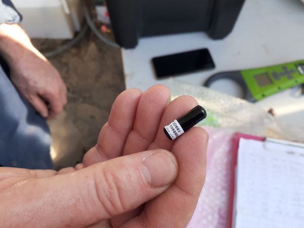
Acoustic transmitter. Photo credit: ARI
Radio transmitters, using the Very High Frequency (VHF) wavelength band, can track animals in both aquatic and terrestrial environments. Transmitters are usually fitted as a collar, harness, attached with glue onto the animal, or implanted into fish.
When in the field, researchers use both automated and handheld receivers to pick up radio signals emitted by the transmitters. The receiver will beep louder or more frequently the closer the researcher is to the transmitter, providing a location.
Prior to the emergence of satellite tracking technology, radio transmitters were often used to understand and monitor the movements and behaviour of individuals in the landscape and how they were impacted by management or conservation actions. They are still a cost-effective option, especially for very small species.
Related projects:
- Tracking catfish implanted with radio transmitters at Tahbilk Lagoon
- Investigating the impacts of strategic fuel breaks as barriers to the movement of the nocturnal Smoky Mouse using radio collars.
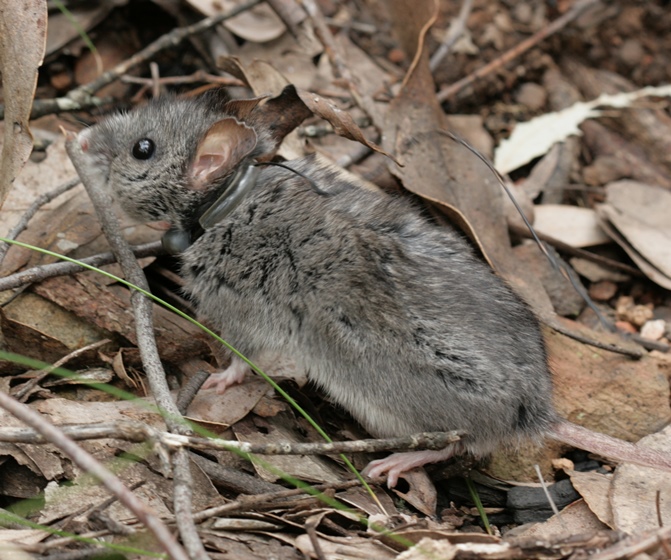
Smoky Mouse with radio collar. Photo credit: ARI
Satellite technology allows researchers to track animals that travel long distances. These devices connect to satellite systems and allow researchers to get accurate locations of tracked animals wherever they are in the world.
With technological advancements in recent years, trackers have become smaller, lighter, longer lasting and cheaper. They can also collect additional environmental data, and some device types allows researchers to track their location live.
For very small animals current GPS technology does not allow for remote data download. Instead, these devices can be combined with VHF technology to help researchers retrieve devices in the field and then download the data.
Related Projects:
- Tracking eel migration using satellites
- Tracking waterbirds to understand how they use wetlands
- Satellite tracking on Brolga to understand movements and nesting choices
- Pairing VHF radio with GPS trackers to learn about foraging flights of Southern Bent-wing Bats
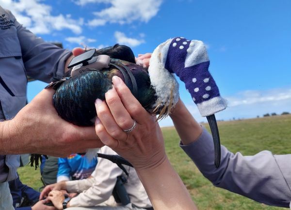 Straw-necked Ibis in process of getting GPS hardness fitted. Photo credit: ARI | Southern Bent-wing Bat flying with attached VHF/GPS tracking unit. Photo credit: Dennis Matthews |
Photographs can also be used to track the movements of individuals in a population. Individuals can be distinguished from their unique physical appearance such as colour, unique marking or patterns, or scars from injury.
This method is useful in cases where placing a tracker on an animal is not feasible. A few ways we collect photo images of individuals include camera traps, aerial image from drone or plane, and citizen science programs.
Related projects:
- Identifying Southern Right Whale individuals from pictures submitted to WhaleFace
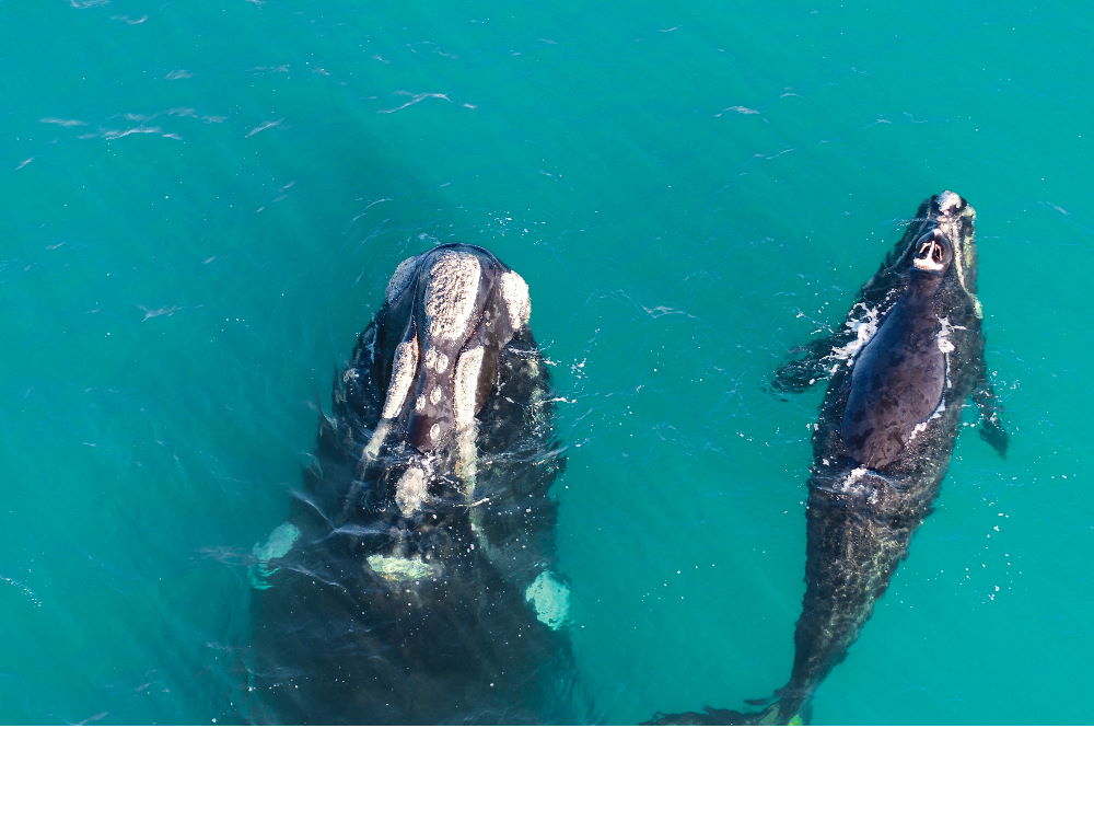
Southern Right Whale with calf - image taken under research permit (no. 10010359) under Section 78 (1) (c) of the Wildlife Act 1975 and Animal Ethics approval (AEC 22-001)
Considerations in tracking wildlife
When choosing a method to track wildlife, researchers must carefully consider the ethical, practical and logistical factors of the project. Animal ethics approval is required in all tracking studies to ensure marking of the animal or the fitting of devices have minimal impacts on the animal’s welfare.
The suitability of which method to use also depends on the ecological question being addressed, the target species and budget availability. Each method also comes with its own capabilities including:
- Longevity of the tracker, i.e. if it is a permanent marker on the individual, how degradable the material used to attach to animal, and battery life.
- Signal range or location and distance from receiver.
- Environmental measures, i.e. temperature, water depth, elevation.
Our expertise
Our researchers have years of experience and knowledge on various methods to track wildlife, both traditional and emerging new technologies, that we apply in our projects. ARI can provide expert support:
- Project guidance – advice on the suitability and effectiveness of the method for your research goals and the animal ethics requirements.
- Methods development – assist in designing the research methods to effectively collect and analyse the data.
- Fill knowledge gaps – deliver targeted research to fill knowledge gaps of the target species.
More information
For more information about ARI tracking wildlife, contact research.ari@deeca.vic.gov.au
You can watch the 2025 ARI Seminar “Navigating barriers – fish movements in rivers” with Dr Zeb Tonkin and Justin O’Connor.
Publications
- Howard, K., Durkin, L., Scroggie, M. and Ward, K. (2023). The Living Murray – Turtle and Frog Condition Monitoring in Barmah–Millewa Forest. Report for the 2022–2023 survey season. ARI Technical Report Series No. 367
- Murray River resnagging experiment fact sheet
- Jones, M. et al. (2025) More than the sum of their parts — Environmental flows increase fish movement and fishway functionality. Ecological Engineering 214 (2025) 107566.
- van Harten, E., Lawrence, R., Lumsden, L. F., Reardon, T., Bennett, A. F., & Prowse, T. A. (2022). Seasonal population dynamics and movement patterns of a critically endangered, cave-dwelling bat, Miniopterus orianae bassanii. Wildlife Research, 49(7), 646-658.
- Jones, M. et al. (2025) Overwintering, recruitment and residency of native fish in the Barmah-Millewa Forest and associated waterways. ARI published Report.
- Koster, W.M. et al. (2020) Environmental influences on migration patterns and pathways of a threatened potamodromous fish in a regulated lowland river network. Ecohydrology
- Koster et al. (2020) Habitat use, movement and activity of two large-bodied native riverine fishes in a regulated lowland weir pool. J Fish Biol. 2020; 96:782–794.
- Lentini, P. E., Cripps, J. K., Bush, A. J., & Lumsden, L. F. (2024). A confirmed range extension for the south‐eastern long‐eared bat (Nyctophilus corbeni) into the central Victorian Murray corridor. Austral Ecology, 49(11), e70007.
- Lyon, J. P. et al. (2019). Increased population size of fish in a lowland river following restoration of structural habitat. Ecological Applications 29(4): e01882. 10.1002/eap.1882
- Robley, A., Ramsey, D., Woodford, L., Taglierini, A., Walker, J., Sloane, P. and Luitjes, M. (2017). Towards a feral Cat management strategy for Hattah–Kulkyne National Park: estimation of feral Cat density and bait uptake rates, and comparison of management strategies. ARI Technical Report Series No. 281.
- Koster, W. M., Westerberg, H., Dawson, D., Kahsnitz, R., Aarestrup, K., & Fanson, B. (2025). Revealing the oceanic spawning migrations of Australian long-finned eels (Anguilla reinhardtii) via satellite telemetry. Frontiers in marine science, 12, 1690502.
- Veltheim, I., Cook, S., McCarthy, M. A., Palmer, G. C., & Hill, F. A. R. (2022). Partial migration of Brolgas (Antigone rubicunda) within a restricted range is revealed by GPS tracking. Emu - Austral Ornithology, 122(1), 39–50.
Page last updated: 30/06/26